MEaSUREs

Making Earth System Data Records (ESDR) for Use in Research Environments (MEaSUREs) is a NASA initiative to build long-term, consistent data records across the globe. Land Surface Temperature and Emissivity (LST&E) data are critical variables for monitoring the long-term effects of climate change and studying a variety of Earth surface processes and surface-atmosphere interactions such as evapotranspiration, surface energy balance and water vapor retrievals. LST&E have been identified as an important ESDR by NASA and many other international organizations including the Global Climate Observing System (GCOS), which recently included LST as an Environmental Climate Variable (ECV). Accurate knowledge of the LST&E at high spatial (1km) and temporal (hourly) scales is a key requirement for many energy balance models to estimate important surface biophysical variables such as evapotranspiration and plant-available soil moisture. Currently LST&E products are produced using different retrieval methodologies resulting in discontinuities in the time-series, and no single satellite exists that is capable of providing global LST&E products at both high spatial and temporal resolution. LST&E data products are currently created from sensors in low earth orbit (LEO) such as the NASA Moderate Resolution Imaging Spectroradiometer (MODIS) instruments on the Terra and Aqua satellites, as well as from sensors in geostationary Earth orbit (GEO) such as the Geostationary Operational Environmental Satellites (GOES). Sensors in LEO orbits provide global coverages at moderate spatial resolutions (~1km) but more limited temporal coverage (twice daily), while sensors in GEO orbits provide more frequent measurements (hourly) at lower spatial resolution (~3-4km) over a geographically restricted area.
The MEaSUREs LST&E products are built through collaboration between the Jet Propulsion Laboratory, University of Wisconsin Madison, University of Maryland College Park, and the United States Department of Agriculture (USDA).
The following long-term data records are currently in production:
|
ESDR’s |
Spatial resolution |
Coverage |
Temporal resolution |
Time period |
|
LEO LST |
0.25, 0.5, 1° |
Global |
Monthly |
2002-2024 (2029)* |
|
GEO LST |
4 km |
N. and S. America |
N. America – hourly S. America – 3 hourly |
2002-2024 (2029)*
|
|
LEO LSE* (CAMEL v3) |
5 km |
Global |
Monthly |
2002-2024 (2029)* |
* Proposed end date for continuation of products in MEaSUREs 2022 solicitation. NOTE: Current project began in 2019 and will end in 2024.
The CAMEL data is available from the LP DAAC. The algorithm theoretical basis document describes the full algorithm.
The GEO-LST data is available from the LP DAAC. The algorithm theoretical basis document describes the full algorithm.
Product: LSE-ESDR
Name: Combined ASTER/MODIS Emissivity over Land (CAMEL)
Status: The CAMEL data is available from the LP DAAC.
The Combined ASTER MODIS Emissivity for Land (CAMEL) dataset was developed by merging the MODIS-based UW-Madison Baseline Fit Emissivity (UWIREMIS) and the monthly ASTER Global Emissivity Dataset (ASTER GED v4) produced at JPL. The CAMEL dataset capitalizes on the unique strengths of the spatial and spectral characteristics of each product in the infrared region. A limitation of the MODIS-based UWIREMIS dataset is that the emissivity in the TIR region (8-12 µm) is not well defined because MODIS only has three bands in this region (bands 8.5, 11 and 12 µm). This results in an imperfect TIR spectral shape in the two quartz doublet regions at 8.5 and 12 µm. The advantages of the UWIREMIS dataset are its moderate spatial resolution (5km), uniform temporal coverage (monthly), and coverage of the entire IR region (3.6-12 µm). An advantage of the ASTER-GED is that there are more bands to define the spectral shape in the TIR region (5 bands, 8-12 µm), but no bands in the mid-wave infrared (MIR) region around 3.8-4.1 µm, which limits its use in models and other atmospheric retrieval schemes. The ASTER-GED product advantages are its high spatial resolution (~100m) and high accuracy over arid regions using the TES retrieval technique. CAMEL Version 1 (v1) and Version 2 (v2) have been available at LP DAAC since 2017 and 2019, respectively, for the period 2000 through 2016 at 0.05-degree (~5km) resolution in mean monthly time steps. CAMEL consists of three main products: a) the 13-hinge points emissivities, b) the uncertainties, and 3) the principal component regression coefficients for deriving high spectral resolution spectra.

Fig 1: Emissivity versus wavelength
A high spectral resolution (HSR) emissivity software has been also developed and is available with the monthly mean regression coefficients at LPDAAC. The CAMEL HSR emissivity software creates a high spectral emissivity on 417 wavenumbers using a Principal Component Analyses (PCA) regression described in Borbas et al (2018) with some changes (see details in the CAMEL User guide). The version 2 update focused on improving the partially snow-covered scene by adding two additional laboratory sets as the combination of the snow/ice emissivity spectra and non-snowy emissivity spectra of lab datasets. Currently, we are developing CAMEL v3 to be able to extend the dataset up to 2023. The Col4.1 MOD11C3 inputs are being replaced with the combination of Col 6.1 MOD11 and MOD21 to improve the product accuracy and reduce systematic and time-dependent errors.
| Institution | Intended Use/Implementation | Contact |
| JPL | Used to initialize quartz and feldspar abundance for modeling dust transport for the EMIT mission | Vince Realmuto, Robert Green |
| UK Metoffice | Implemented in RTTOV radiative transfer code v11-v13 | Jerome Vidot |
| JPL | Used as first guess for emissivity in the Plume-tracker software for mapping of volcanic sulfur dioxide emissions | Vince Realmuto |
| CLIMCAPS team | Operational NASA CLIMCAPS sounder atmospheric retrieval scheme (CrIS/ATMS) | Chris Barnet & Nadia Smith |
| CIMSS | CSPP Hyperspectral Retrieval Software (IASI, AIRS and CrIS) | Elisabeth Weisz |
| NOAA/CIMSS | CLAVR-X – clear sky radiative transfer calculation | Mike Foster |
| JPL | AIRS PAN retrieval | Vivienne Payne |
| UMBC | Climate trend from high spectral resolution satellite data | Larrabbe Strow |
| EC | Environmental Canada, data assimilation | Louis Garand |
| NRL | Naval Research Lab, data assimilation | Ben Ruston |
| Meteo-France | Data assimilation | Vincent Guidard |
| DWD | German Meteorological Office data assimilation | Christina Koepken |
| SSEC/GEOCAT | GEOCAT Radiative transfer calculation | Graeme Martin |
| EUMETSAT | MeteoSwiss Data assimilation | Anke Duguay |
| CIMSS | MODIS/VIIRS atmospheric water vapor retrievals (MxD07, VNPWATVP) | Eva Borbas, Paul Menzel |
| JPL | LST retrievals and first guess in AIRS optimal estimation retrievals | Glynn Hulley, Bill Irion |
Product: Low Earth Orbit – Land Surface Temperature (LEO-LST)
Status: The LEO-LST product pipeline for v1 has been generated and the ingest process and documentation has completed at the LPDAAC. The product is expected to be released in July- August 2022.
The primary goal of the LEO-LST ESDR product is to develop a long-term, stable record of LST over land that bridges gaps seamlessly between sensors. The product is generated by re-gridding the monthly Climate Modeling Grid (CMG) products from MODIS-Aqua starting in 2002 and VIIRS starting in 2011 and making them available on 0.25, 0.5, and 1-degree optimized climate grids with well characterized per-pixel uncertainties. The LEO-LST record starts from MODIS Aqua in 2002, merges with the VIIRS-SNPP in 2011 and after Aqua’s orbit starts to drift to a later mean local time (MLT) in early 2023, we plan to remove MODIS and add in VIIRS LST from NOAA-20 (VJ121) to ensure continuation of the LEO-LST 1:30 am/pm ESDR until 2029. Figure 1-7 shows good agreement between the VNP21 (SNPP) and VJ121 (NOAA-20) products with an RMSE of 1.4 K (bias
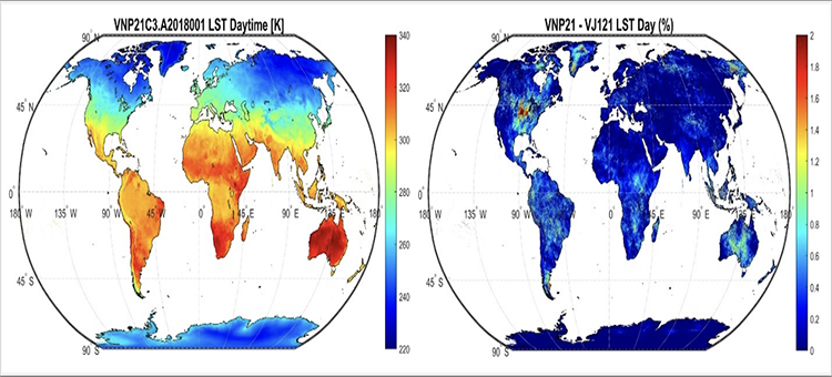
Fig 2: The VNP21C3 LST product (left), and differences with the new VJ121 LST product from NOAA-20 (right) that will continue the LEO-LST time series beyond MODIS in 2023.
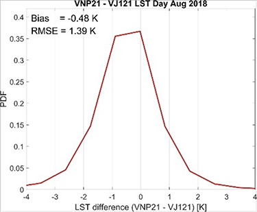
Fig 3: Differences between the VNP21 and VJ121 LST are within acceptable limits at
The long-term LEO-LST record is used by the global climate modeling community, for example in Observations for Model Intercomparisons Project (obs4mips). Obs4mips is an activity to make observational products such as LST more accessible for climate model intercomparisons and evaluation. It provides data specifications that are closely aligned with the Coupled Model Intercomparison Project (CMIP) making it possible to make data available via the same searchable distributed system used to serve and disseminate the rapidly expanding set of simulations made available for community research.
The product pipeline has been generated and the ingest process at the LPDAAC has begun. The product will be released in Summer 2022. The benefits of the LEO-LST have been illustrated through examples of past MODIS LST data used for climate studies and include measuring climate warming trends on global scales in addition to over specific land cover types such as over Greenland, inland water bodies, and urban areas. Just recently, the LEO-LST data were used by this team to investigate the extreme heat crises currently unfolding over India and Pakistan in 2022 where oppressively hot temperatures arrived earlier than normal and persisted with unprecedented longevity through March and April severely affecting food production (wheat), and resulting in fires and death. Figure 1-2 shows an example of the LEO-LST product for the month of March over the region, and the LST anomaly relative to the past 20 years. Large anomalies of up to 10 degrees can be seen in part of Pakistan, Afghanistan and the northern parts of India with intensive agricultural practices (e.g. around Delhi).
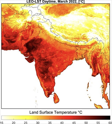
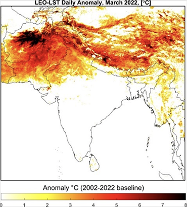
Fig 4: Example of the use of the LEO-LST product for assessing global heatwave events and trends such as the ongoing extreme heatwave over the Indian subcontinent. (Left) LEO-LST average daytime LST for March 2022, and (right) the LEO-LST anomaly relative to a 20-year baseline from 2002-2022.
Product: GEO LST-ESDR
Status: Data is available from LP DAAC.
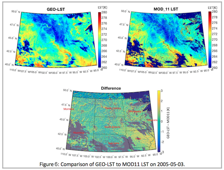
Method: LST information is derived from the GOES satellites from 2000 and onward. Atmospheric correction is done using MERRA-2 reanalysis fields with the RTTOV radiative transfer model, adjusted for the GEO characteristics, and CAMEL is used for the emissivity. The advantage of this approach is its consistency with the retrieval approach used at JPL to generate the MOD21 product.

Relevant Publications
Chen, W., Pinker, R.T., Ma, Y., Hulley, G., Borbas, E., Islam, T., Cawse-Nicholson, K.A., Hook, S., Hain, C. and Basara, J., (2021). Land Surface Temperature from GOES-East and GOES-West. Journal of Atmospheric and Oceanic Technology. https://doi.org/10.1175/JTECH-D-20-0086.1
Loveless, M., Borbas, E.E., Knuteson, R., Cawse-Nicholson, K., Hulley, G., and Hook (2021) Climatology of the Combined ASTER MODIS Emissivity over Land (CAMEL) Version 2.Remote Sens, 2021, 13, 111. https://doi.org/10.3390/rs13010111
Borbas E., and M Feltz (2019): Updating the CAMEL surface emissivity atlas for RTTOV, Report of Visiting Scientist mission NWP_AS18_01, Document NWPSAF-MO-VS-058, Version 1.0, 18-01-19, https://www.nwpsaf.eu/publications/vs_reports/nwpsaf-mo-vs-058.pdf
Pinker, R.T., Ma, Y., Chen, W., Hulley, G., Borbas, E., Islam, T., Hain, C., Cawse-Nicholson, K., Hook, S., Basara, J. (2019). Towards a unified and coherent land surface temperature earth system data record from geostationary satellites. Remote Sensing, 11(12), 1399. https://doi.org/10.3390/rs11121399
Borbas, E.E., Hulley, G., Feltz, M., Knuteson, R., Hook, S. (2018). The Combined ASTER MODIS Emissivity over Land (CAMEL) Part 1: Methodology and High Spectral Resolution Application, Remote Sensing, 10(4), 643. https://doi.org/10.3390/rs10040643
Feltz, M.; Borbas, E.; Knuteson, R.; Hulley, G.; Hook, S. (2018) The Combined ASTER MODIS Emissivity over Land (CAMEL) Part 2: Uncertainty and Validation. Remote Sens. 2018, 10, 664. https://doi.org/10.3390/rs10050664
Feltz, M.; Borbas, E.; Knuteson, R.; Hulley, G.; Hook, S. (2018) The Combined ASTER and MODIS Emissivity over Land (CAMEL) Global Broadband Infrared Emissivity Product. Remote Sens. 2018, 10, 1027. https://doi.org/10.3390/rs10071027
Yang, Y., Anderson, M.C., Gao, F., Wardlow, B. Hain, C.R., Otkin, J.A., Alfieri, J., Yang, Y., Sun, L., Dulaney, W. (2018). Field-scale mapping of evaporative stress indicators of crop yield: An application over Mead, NE, USA, Remote Sensing of Environment, 210 387-402. doi:10.1016/j.rse.2018.02.020
Sun, L., Anderson, M.C., Gao, F., Hain, C.R., Alfieri, J.G., Sharifi, A., McCarty, G.W., Yang, Y., Yang, Y., Kustas, W.P., McKee, L. (2017). Investigating water use over the Choptank River watershed using a multi-satellite data fusion approach, Water Resources Research, 53 (7), 5298-5319. doi:10.1002/2017WR020700.
Yang, Y., Anderson, M.C., Gao, F., Hain, C.R., Semmens, K.A., Kustas, W.P., Normeets, A., Wynne, R.H., Thomas, V.A., & Sun, G. (2017). Daily Landsat-scale evapotranspiration estimation over a managed pine plantation in North Carolina, USA using multi-satellite data fusion. Hydrol. Earth Syst. Sci., 21, 1017-1037. doi:10.5194/hess-21-1017-2017
Yang, Y., Anderson, M.C., Gao, F., Hain, C., Kustas, W.P., Meyers, T., Crow, W., Finocchiaro, R.G., Otkin, J.A., Sun, L., & Yang, Y. (2017) Impact of tile drainage on evapotranspiration (ET) in South Dakota, USA based on high spatiotemporal resolution ET timeseries from a multi-satellite data fusion system. J. Selected Topics in Applied Earth Obs. and Remote Sensing., 10 (6) 2550-2564. doi:10.1109/JSTARS.2017.2680411
Borbas et al., 2015: A Unified and Coherent Land Surface Emissivity Data Record, (poster) 20th International TOVS Study Conference, Lake Geneva, WI, USA, Oct 28-Nov 3, 2015.
Borbas et al., 2015: A Unified and Coherent Land Surface Temperature and Emissivity (LST&E) Earth System Data Record (ESDR) for Earth Science Research (poster). AGU Fall Meeting, San Francisco, CA, USA, Dec 14-18 2015
Hulley, G., Hook, S., and E. Abbott (2015), The ASTER Global Emissivity Dataset (GED): Mapping Earth's emissivity at 100 meter spatial resolution, Geophysical Research Letters. Geophys. Res. Lett., 42, doi:10.1002/2015GL065564.
Hulley et al., (2015). MEASURES High Spectral Resolution MODIS/ASTER Emissivity Database, (talk), 20th International TOVS Study Conference, Lake Geneva, WI, USA, Oct 28-Nov 3, 2015.
Knuteson et al., 2015: Uncertainty Estimates of NASA Satellite LST over the Greenland and Antarctic Plateau: 2003-2015. (talk) AGU Fall Meeting, San Francisco, CA, USA, Dec 14-18 2015.
Guillevic, P. C., Hulley, G., Hook, S., Hain, C., Anderson, M., Pinker, R., Borbas, E., Knuteson, R. (2014). A Unified and Coherent Land Surface Temperature and Emissivity (LST&E) Earth System Data Record (ESDR) for Earth Science Research. American Meteorological Society (AMS) annual meeting. Phoenix, AZ, 4-8 January 2015.
Hain, C. R., M. C. Anderson, J. Otkin, K. Semmens, X. Zhan, L. Fang and Z. Li, (2014). Use of Land Surface Temperature Observations in a Two-Source Energy Balance Model Towards Improved Monitoring of Evapotranspiration and Drought, 2014 AGU Fall Meeting, San Francisco, CA, 15-19 December 2014.
Hain, C. R., M. C. Anderson, J. Otkin, K. Semmens, X. Zhan, L. Fang and Z. Li, (2014). ALEXI and Use of S-NPP for Vegetation, Evapotranspiration and Drought, Secon Suomi NPP Applications Workshop, Huntsville, AL, 18-20 November 2014.
Hulley, G., Malakar, N., Hook S., and P. Guillevic (2014), A unified MODIS Land Surface Temperature (LST) Earth System Data Record, RAQRS 2014, Valencia, Spain, 22-26 September 2014
Hulley, G., Hook S., Guillevic P., Sanchez, J-M, (2014), A unified MODIS Land Surface Temperature (LST) and Emissivity Earth System Data Record, AGU Fall Meeting 2014, San Francisco, CA, 14-19 Dec 2014
Hulley, G., Hook S., Guillevic P., Sanchez, J-M, (2014), A unified MODIS Land Surface Temperature (LST) and Emissivity Earth System Data Record, AGU Fall Meeting 2014, San Francisco, CA, 14-19 Dec 2014
Knuteson, R, E. Borbas, G. Hulley, S. Hook, M Anderson, R. Pinker, C. Hain and P. Guillevic, (2014). A Unified and Coherent Land Surface Emissivity Earth System Data Record, Poster, AGU Fall Meeting, San Francisco, 15-19 December 2014. https://wiki.earthdata.nasa.gov/download/attachments/43321891/AGU2014_Borbas_MEaSUREs_poster.pdf?api=v2
Hulley, G. C., T. Hughes, and S. J. Hook (2012), Quantifying Uncertainties in Land Surface Temperature (LST) and Emissivity Retrievals from ASTER and MODIS Thermal Infrared Data, Geophysical Research Letters, 117, D23113, doi:10.1029/2012JD018506.
Hulley, G., Hook S., and C. Hughes (2012), A unified MODIS Land Surface Temperature (LST) Earth System Data Record, GlobTemp Meeting, Edinburgh, Scotland, June 2012